Weather-shaped islands

Faroe Islands

An Atlantic archipelago of steep green islands, compact settlements, tunnels and weather that continually redraws the relationship between land and sea.

Sea cliffsIsland villagesAtlantic weather

Location
North Atlantic, Faroe Islands
Best window
May-Sep
Suggested stay
3-5 days
Go for
North Atlantic circuit
The reason to go

Village coastlines

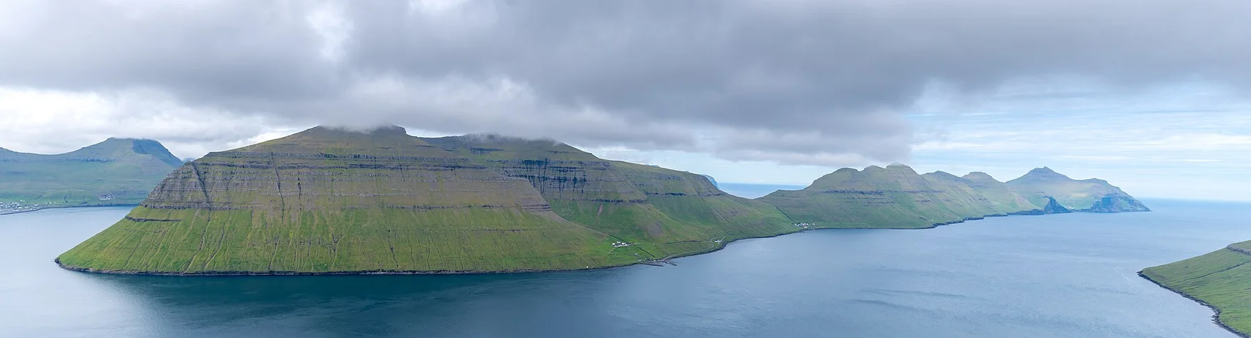
Settlements occupy narrow coastal shelves and reveal how daily life adapts to steep terrain and changing weather.

Plan the least frequent boat, ferry or exposed coastal section first. Use early or late light and keep a weather alternative during May-Sep.

Look a little closer

Worth discovering

The details that make Faroe Islands different.

Destination view
01

Village coastlines

Settlements occupy narrow coastal shelves and reveal how daily life adapts to steep terrain and changing weather.

Photo journal
02

Cliffs and waterfalls

Layered rock faces and streams falling directly toward the ocean create the archipelago's strongest vertical forms.

Destination view
03

Connected islands

Tunnels, bridges and ferries turn the landscape into a continuous route while preserving the identity of each island.

Photo journal

A closer look at Faroe Islands

15 photographs
Beyond the surface

What made Faroe Islands distinctive

An Atlantic archipelago of steep green islands, compact settlements, tunnels and weather that continually redraws the relationship between land and sea. The view is only the surface of a longer story of formation, use and change.

The Faroe Islands form a compact archipelago between the North Atlantic and Norwegian Sea. Eighteen main islands combine high sea cliffs, narrow fjords, grass-covered slopes and villages positioned wherever the terrain offers a usable shelf. Bridges, ferries and subsea tunnels make it possible to experience many distinct landscapes within relatively short driving distances.

Many visits to Faroe Islands begin with the experience described as “Village coastlines”. The more revealing question is why it exists here, how people used the surrounding ground and what remains visible from earlier phases. Settlements occupy narrow coastal shelves and reveal how daily life adapts to steep terrain and changing weather.

Continue to practical planning
Faroe Islands — view 4See the complete photo journal
Natural history

The forces behind the first impression

Before roads, settlements or protected-area boundaries, the terrain of Faroe Islands set the basic terms. The islands are built from layered volcanic rock, cut by glacial valleys and constantly exposed to wind, cloud and ocean swell. Waterfalls frequently drop toward the sea, while ridges can move from clear to hidden within minutes. The lack of broad lowlands makes every road, field and settlement appear closely negotiated with the topography.

The map understates the role of the sea. At Faroe Islands, “Village coastlines” makes clear that water is both a boundary and the route through which settlements, wildlife and outside connections developed. Settlements occupy narrow coastal shelves and reveal how daily life adapts to steep terrain and changing weather.

Cultural landscape

Settlement, movement and local knowledge

At Faroe Islands, human history is written into settlement and land use rather than separated from the scenery. Torshavn provides an urban centre, but much of the archipelago's character lies in smaller settlements such as Gjogv, Saksun, Tjornuvik and Gasadalur. Turf-roofed buildings, working harbours and sheep pasture remain part of everyday land use. Infrastructure has reduced isolation without erasing the distinct scale of individual islands.

At Faroe Islands, the feature described as “Cliffs and waterfalls” offers a second line of evidence. Layered rock faces and streams falling directly toward the ocean create the archipelago's strongest vertical forms. Within Faroe Islands, it shows how local knowledge and practical use became embedded in the landscape.

Change

The change that redefined the place

The decisive modern change at Faroe Islands was access. At Faroe Islands, transport and visitor infrastructure made the landscape easier to reach while concentrating pressure at the few points where roads, boats or trails enter it. At Faroe Islands, the consequences are clearest where traditional use, protection and tourism occupy the same ground.

Visible evidence

Three details that explain the whole place

Look closely at the feature “Village coastlines” in Faroe Islands; it carries information that a panoramic view can miss. Settlements occupy narrow coastal shelves and reveal how daily life adapts to steep terrain and changing weather. At Faroe Islands, the detail links local scale with the wider regional pattern.

Look closely at the feature “Cliffs and waterfalls” in Faroe Islands; it carries information that a panoramic view can miss. Layered rock faces and streams falling directly toward the ocean create the archipelago's strongest vertical forms. At Faroe Islands, the detail links local scale with the wider regional pattern.

At Faroe Islands, the significance of the feature “Connected islands” goes beyond its visual impact. Tunnels, bridges and ferries turn the landscape into a continuous route while preserving the identity of each island. For Faroe Islands, that relationship is more informative than treating the feature only as a photograph or checklist item.

Season and scale

A living landscape, not a frozen scene

A single visit to Faroe Islands captures only one phase of its annual cycle. Late spring and summer provide the longest daylight, the broadest ferry schedules and the best access to walking routes. Weather remains variable even in July, so clear intervals are often more important than fixed plans. Autumn and winter bring stronger storms, limited daylight and a more demanding but highly atmospheric island experience.

For Faroe Islands, the main seasonal constraint is: the strongest planning window is May-Sep. For Faroe Islands, outside it, check weather, daylight, road or ferry schedules and seasonal closures before committing to a fixed route.

For Faroe Islands, one practical detail matters: ferries, tunnels and weather can change the order of the day. For Faroe Islands, build the route around the least frequent connection, not the closest viewpoint.

Placed within its wider geography, Faroe Islands is not an isolated exception. For Faroe Islands, the wider context shows that, the archipelago rewards movement beyond the most shared viewpoints. For Faroe Islands, northern islands, western cliffs, smaller ferries and village roads reveal variations in geology and settlement that a single scenic stop cannot represent. For Faroe Islands, kalsoy, already part of the Rediscover Earth atlas, is one focused expression of this larger island system.
Travel notes

Plan your visit

Time needed
3-5 days
Getting around
Car or local transport, plus ferries or boats and short walks
Effort
Moderate
Plan first
Main transport and accommodation
Time of day
Start early for clearer conditions and more time
Best window
May-Sep
Traveller stories

Stories from people who have been here.

First-hand moments, practical notes and overlooked details from Faroe Islands.

Loading traveller stories…

Browse all traveller stories ↗

Keep exploring

Where next?

All place stories